more information inside…

STEP #2 – THE CROSS BORNEO TREK (OR CBT)
Usually you would walk every day from 7:00 until 14:30/15:00, it means from 7 to 8 hours lunch and countless pauses to regain strength and stamina included.
The pace would be around 1km/h (stops included), so the covered distance would not be so much, but 1 km in the rain forest is like 10 km in our forest… just to understand better please go to day 5 of the trekking report.
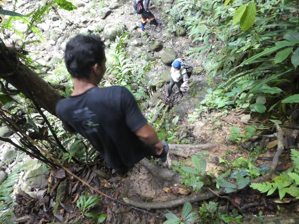
Along the path everything is slippery, the rocks in the rivers, the green moss on rocks and trunks, the omnipresent roots and mud… in one word, everything!
Furthermore there are uprooted trees all over your path, and sometimes they are the path itself… It means that you should pay attention every single minute, and have the highest carefulness: before moving one foot you should be sure as eggs is eggs that your other foot is steady (as far as possible) and that the roots, the trees or whatever you are grabbing is well fastened!
The running, especially after one whole night of rain, could be murderously energetic, so grab whatever you can, lianas, porters (if they could be on their feet…) and try, whenever is possible, to have your feet on the sand, that increase your grip.
MUARA HUBUNG – ATIKOP HILL – MUARA SAITE – LESS DEMANDING – 3KM – 3 HOURS – ↑310 M ↓190 MThe starting point is a sneak peek of CBT… A steep climb, with mud slippery like soap, with some less slithery roots scattered here and there. Then through the secondary forest down to the river where we camped under the typical blue shelter.
Good terrain to sleep, almost >lat, the river is wide and good to have rest
MUARA SAITE – SUNGAI BEKANA – ARINGE – LESS DEMANDING – 6KM – 5 HOURS – ↑350 M ↓200 M
Throughout primary rain forest, the trek is going deeper and deeper. The path is almost >lat, pretty simple to follow and it is not so dif>icult. There is just only some few meter on the way where you need to be extremely careful: a wet slippery stony wall before the woody gravestone of the Dutch felt down and dead in this point…
Good terrain to sleep, almost >lat, the river is wide and good to have rest
ARINGE – MULLER RANGE – DEMANDING – 4,5KM – 5HOURS – ↑650 M ↓100 M
The day target was to reach Muller Range the highland between East and West Borneo where we camped.
The climb is deathly demanding and in some case you should literally climb by using roots, or whatever you would >ind at your disposal!
You would gain 600m in only 2km… not to mention the countless up and down… About 70° of gradient
To quote our live comments “it is like climbing the North Face of the Eiger, without ice, but in a 40 degrees steam-bath, with mud and roots all over, where trees are just split on the terrain and stand against g- force…”
On the top, the wonderful unfailing mist of rain forest, and a huge amount of leeches! The eyeshot and the vegetation are unspeakably breath-taking.
Terrain to sleep: Terribly bumpy, full of roots, stones and tree branch broken, de>initely not >lat. Full of sweat wasps. The river is narrow and reachable by muddy slope. Really cold at night! If you could use the tent of the people that are building the road, it would be the best!
MULLER RANGE – SUNGAI SABANG – REALLY DEMANDING – 5KM – 5HOURS – ↑100 M ↓650 M
Down the hill, passing the border between East and West Borneo on Muller Range. The descent takes less than the ascent, but at the beginning is highly demanding. I do advice not to climb and go down in the same day, it would be too much effort and too dangerous!
After that you will start to cross rivers with higher and higher running.
In some part of the path you need to climb or go down using lianas or ropes
Terrain to sleep: Terribly bumpy, full of roots, stones and broken branches, a parody of >latness. The river is wide and reachable. Cold at night.
SUNGAI SABANG – BUNGAN LEA – EXTREMELY DEMANDING – 3KM – 3,5HOURS – ↑190 M ↓120 M
The trekking continues through hills and rivers…
These were the most challenging, exhausting, lengthy and dangerous 3km of whole my life! I will remember this day forever!!!
First of all it was the 5th day of jungle food, of trekking and the 3rd day of my menstrual cycle and the 2nd day of light diarrhoea… No food left with good nutritional value, but especially it was raining the whole night and our path, “the river”, completely swollen; the new path, the banks of the river, partially collapsed and clogged by fallen uprooted trees, part of it, landslides, mudslides, with danger of slides…
We crossed the river more than 50 times, we crossed landslides areas trying to stand on our feet as we could, through an imaginary undrafted path, through the cragged waterside of the torrential running river.
Trees or part of it, landsides, softy crumbly soils, rocks, series of ups and downs most of the time extreme and only lianas, ropes, roots to grab. All around us everything was slippery!
A real thrilling adventure, even if dangerous beyond measure!
Terrain to sleep: almost >lat, some stones. The river is wide and reachable, but the running is torrential.
BUNGAN LEA – BRAKAN – REALLY DEMANDING – 4KM –4 HOURS – ↑250 M ↓300 M
Trekking along the river stone and rookies land, up and down the hill
Almost the same as the day before, but less challenging. As it was not raining, we could walk into the river and on the real path.
Some uprooted trees, some landslides.
Brakan is a village of miners and you could buy food, cigarettes, rice, sugar…
Terrain to sleep: almost >lat, some roots and woods. The river is wide and reachable.
BRAKAN – SUNGAI BULIT – DATAH OPET – LESS DEMANDING – 5KM – 4,5HOURS – ↑150 M ↓150 M
Through mud with dry leaves and twig and hills
Easy hiking compared to the previous days, almost >lat on dry leaves, mud and woods. Some challenging points along the path, but a piece of cake in comparison with the ones of the previous days.
We visited the >irst caves and we camp right before the last ascent.
Terrain to sleep: Terribly bumpy, full of roots, stones and tree branch broken, a parody of >latness. The river is tiny, but reachable.
DATAH OPET – BURU HONGKANE – TANJUNG LOKANG VILLAGE – DEMANDING – 5KM – 4HOURS – ↑350 M ↓400 M
Reaching Tanjung Lokang village by climbing the hills
The ascent is really challenging, but not as much as the one in Muller Mountains. All around is full of caves. To visit it you need to ask a special permit to the Government as the local people are collecting the expensive bird nest
On the top there is a huge cave with some burial sites.
During the descent we found out a trees landslides really challenging, Just before reaching Tanjung Lokang we went through a deep forest of fern, full of mosquitoes…
We slept in Putussibau.
In case you would sleep in Tanjung Lokang, the Guest House is big, open and with a good wooden >loor. Toilets have no running water, but buckets full of water to have a shower.

